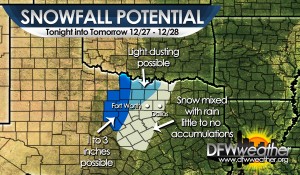
As our much advertised vigorous upper-level storm system moves across the area this evening, rain will become mixed with sleet and snow from west to east in the areas depicted in the map below. The highest accumulations are expected mostly outside our extreme western counties where 1 to 3 inches are possible and a Winter Weather Advisory has already been hoisted by the National Weather Service office in Fort Worth. A dusting to under an inch will be possible in our northwestern counties. Closer in to the heart of our forecast area, wet snow flakes will be mixing in with the rain with a brief window for a transition to all snow early tomorrow morning before precipitation shuts off. However, temperatures will be at or above freezing and coupled with recent warm grounds, we expect little to no accumulations in these areas.
Tag Archives: snow
PRELIMINARY SNOWFALL TOTALS

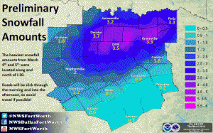
Preliminary snowfall totals for the March 4-5, 2015 storm. Map courtesy of the National Weather Service office in Fort Worth, Texas.
The graphic above shows the preliminary snowfall totals for the March 4th and 5th storm of 2015. The heaviest amounts were along and north of I-30. Most of this snow fell on top of a thin layer of ice and about a 1/4 to 1/2 inch of sleet. This event is the 4th heaviest snowfall on record for the month of March at DFW officially with 3.5 inches. Other notable March winter storms are as follows:
1. March 13, 1924 – 6 inches
2. March 1, 1942 – 4.5 inches
3. March 7, 1947 – 3.9 inches
4. March 4-5, 2015 – 3.5 inches
5. March 17-18, 1934 – 2.5 inches
THREE MORE CHANCES OF SNOW AND ICE THROUGH SATURDAY
An Arctic cold front traversed the region this morning advecting much colder air back into the region. Temperatures at this hour were right around freezing, or just below, across the forecast area. A shortwave trough was evident moving across the area on water vapor. This trough is responsible for moderate to strong lift across the region. However, around the Metroplex, there is considerable dry air at the surface to overcome and moisture is rather limited. Farther to the west and southwest of Fort Worth, a snow band has developed in a stronger area of frontogenesis bound by Haskell to Mineral Wells down to Hillsboro resulting in slightly heavier snowfall. Accumulations in this region could reach an inch or so. As a result, the National Weather Service office in Fort Worth has issued a Winter Weather Advisory for Parker and Hood counties in our forecast area. Across the Meteroplex, snow should stay rather light with weaker lift and drier air to overcome, though a dusting to 1/2 inch can’t be ruled out. The snow should taper off as lift decreases this afternoon as the shortwave moves off to the east.
Another stronger and larger shortwave trough will approach the area tomorrow. This trough will be slower to move across the area with longer duration of lift expected. However, moisture will still be limited. Depending on the exact tract of this trough (currently northwest of DFW), the highest snowfall accumulations will occur beneath it. This could change with later model runs, and given setup, the possibility exists for up to 2 inches of snowfall on Friday. With temperatures expected to largely be in the 20s, this could pose some travel impacts. This will be further assessed later in the day with the latest model data once the first system gets out of the picture.
The overall synoptic pattern will undergo a change Friday night through the weekend, that transitions us from a large scale trough in the center of the CONUS to one that favors strong southwest flow aloft. This will intensify overrunning of a warm air and moisture advection pattern aloft. With the Arctic airmass in place and temperatures below freezing Friday night into Saturday, periods of snow changing to sleet changing to freezing rain and drizzle will be possible. This will likely coat roadways with a few one hundredths of an inch of ice to possibly a tenth of an inch of ice with isolated higher amounts over much of the forecast area. This will be enough to cause some moderate impacts to travel Saturday. Temperatures will warm significantly on Sunday as a warm front is pushed across the area in the strong warm air advection pattern. This will effectively end all threat for frozen precipitation with switch back to all liquid rain. Some thunderstorms will be possible by Tuesday as instability increases ahead of another cold front.
WHY MANY MISSED OUT ON THE SNOW FOR THE MOST PART

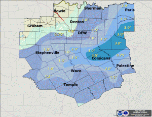
Snowfall totals for the Wednesday, February 25, 2015 snow event. Map courtesy of the National Weather Service office in Fort Worth, Tx.
The upper-low tracking across Texas moved a little farther south than expected. This further south movement allowed temperatures, at about 5000 feet above the surface, to be about 2°F warmer, across the immediate Metroplex and points north, than what they would have been if the core of the low tracked further north. This was enough to effectively have most of the snow that was falling in the upper atmosphere to melt and fall as rain and sleet at the surface. Where the upper low tracked further south, heavier snow did accumulate in a narrow band bound by Hillsboro to Terrell. The heaviest snow was in Navarro County where 3 to 4 inches fell. See graphic above for more detailed snow totals.
The snow/rain/sleet are moving off to the east, and we should see rapid clearing with sun all the way to the I-35 corridor by this afternoon. This will allow temperatures to climb into the 40s this afternoon. Another Arctic cold front is poised to move through the region tomorrow with more snow in the forecast for Friday. Friday’s snow will fall with temperatures in the 20s, but it will be light with not much in the way of moisture or lift because of a weaker wave embedded in the northern jet. Though, there could be some light accumulations.
WINTER WEATHER ADVISORY – POSSIBLY 1 TO 2 INCHES OF WET SNOW WEDNESDAY MORNING
The National Weather Service has downgraded the Winter Storm Watch to a Winter Weather Advisory for 1 to 2 inches of very wet snow with locally higher amounts up to 4 inches under the heaviest bands. The Advisory will cover all counties within the forecast area. The latest data suggests the heavier snows will now be off to our northeast. Thus, the requirement of widespread 4 inches or more of snow for a Winter Storm Warning will not be met. This appears to be a minor headache event and will not cause high impacts to travel. Temperatures, with adequate late winter sunshine, should warm rapidly above freezing tomorrow afternoon melting any snowfall.
The National Weather Service has expanded the Winter Storm Watch to cover all counties within our forecast area. Thus, Ellis, Johnson, and Rockwall were added to the Watch. The Winter Storm Watch is for the potential for heavy wet snow tonight. 2 to 4 inches with locally higher amounts can be expected.
The upper-low that ejected two disturbances across Texas that brought rain, freezing rain, and sleet to the area yesterday and today will eject directly across North Texas. This is a cold-core upper low that will cool thermal profiles all the way to the surface sufficiently to support snow. Depending on the exact tract of this low, heavy bands of convective snow will develop across North Texas. As a result, the National Weather Service has issued a Winter Storm Watch for heavy snow for Tarrant, Dallas, Denton, Collin, Wise, Ellis, Johnson, Kaufman, and Rockwall in our forecast area. The Watch is for Tuesday night into Wednesday morning as the best chance to see accumulating snowfall.
In the short-term, temperatures remain in the mid 20s across the area. Any residual water or slush on roads will refreeze tonight as temperatures drop into the lower 20s. In addition, patchy freezing drizzle may develop across the area glazing roadways with a thin glaze of ice. Residents are urged to proceed with extreme caution when heading out tonight or in the morning.

