- 2009 – Snow remained on the ground from the Christmas Eve blizzard.
- 2000 – Record rainfall of nearly 2″ fell during the evening with temperatures from 32°F to 34°F with some minor freezing rain. However, severe freezing rain occurred north and northeast of the Metroplex.
- 1997 – A few flurries were mixed with rain during the evening. The next morning a blanket of up to ½” of snow covered portions of the Metroplex.
- 1975 – 0.4″ of snow fell on the first almost white Christmas in nearly 50 years.
- 1974 – A trace of sleet was reported.
- 1963 – No snow remained from a 2″ snowfall on December 22.
- 1929 – One of the heaviest snow events in Texas history occurred on December 21. From Clifton to Hillsboro, 24-26 inches of snow fell. A long swath of snowfall in excess of 12 inches stretched from Goldthwaite and Lampasas to Corsicana and Athens. The Waco and Temple/Killeen areas saw 10-16 inches of snow, but only a trace of snow was recorded in Dallas/Fort Worth.
- 1926 – 2″ of snow fell in Fort Worth but melted by afternoon. Dallas received 6.3″ of snow.
- 1914 – There was a trace of snow recorded with a few brief flurries.
- 1887 – A severe ice storm occurred on December 23, resulting in numerous downed trees and telegraph lines. Heavy snow followed on Christmas Eve, with as much as 9 inches falling in Palestine.
- 1879 – 1″ of sleet and snow was on the ground. It was said that the snow and sleet was so compacted that a horse’s hoof did not leave an imprint in the snow.
- 1841 – Three soldiers from a nearby fort were tracking a bear in 6″ of snow near what is now White Rock Lake.
Tag Archives: Holiday
THANKSGIVING DAY HISTORICAL SIGNIFICANT WEATHER EVENTS FOR DFW
- November 22, 2007 – A light wintry mix of sleet and snow fell during a cold afternoon. It was only the second occasion that wintry precipitation fell during a home Dallas Cowboys football game (vs. New York Jets).
- November 25, 1993 – Freezing rain and sleet fell during a subfreezing afternoon, amounting to 0.3″ on the ground. This was the first time that wintry precipitation was ever recorded on Thanksgiving. The low was 23°F and the high was only 35°F, making it the coldest Thanksgiving ever. Also, the annual Thanksgiving Day Dallas Cowboys football game (vs. Miami Dolphins) was the first time wintry precipitation fell during an NFL game in Dallas.
- November 25, 1965 – This hot day reached a record high of 88°F.
- November 22, 1945 – It was the first killing frost of the winter of 1945-46, a low temperature of 31°F.
- November 30, 1905 – The first killing frost of the season was a hard freeze, a morning low of 23°F.
DFW RAINFALL AMOUNT TOTALS AND THANKSGIVING WEEK OVERVIEW
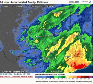
The storm system that brought much needed rainfall to DFW has pushed over to the northeast. In its wake, skies were clear with some patchy fog in some locations which should quickly burn off this morning. Rainfall totals were less than what we forecasted as the system took a much further south track than we thought. However, we did get much needed rainfall across the area, but not everyone saw over an inch of rain as we had hoped with our western and southern counties seeing the most precipitation. Please see the pic for a radar estimate of storm totals.
Another deepening storm system in Colorado will tighten the pressure gradient causing our winds to pick up out of the west today and become quite gusty out ahead of a cold front. High temperatures are going to be very tricky today as compression warming from the front and westerly component to the wind will support a substantial warm-up in the upper 70s. However, the ground is still very wet and will help to offset the warming a bit. Therefore, the official DFW Weather forecast went with the cooler guidance number for highs today in the middle 70s.
The cold front will bring temperatures down a good 15 degrees tomorrow with more seasonable weather. This will setup a beautiful Thanksgiving week for North Texas with seasonal weather. Computer model guidance is showing temperatures rebounding well into the 70s for the Thanksgiving weekend. Last week, it looked like we were going to get another surge of Arctic air, but over the weekend, the models back off this scenario. While here at DFW Weather, we are going for the warmer weather scenario for the official forecast, this forecaster will caution that Arctic air is damming up on the models in Oklahoma and Texas Panhandles. In this type of situation, usually the cold air wins out, and we do get a some sort of frontal passage. This is due, in part, to the fact that cold air is very dense and tends to sink south against the mean flow, and to the fact that models have a hard time in general with placement of shallow/dense-low level cold air. This is something to definitely watch, and the forecast could change drastically next weekend.


