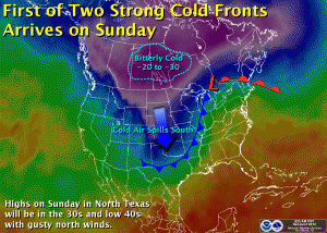
First of two Arctic cold fronts expected this week. Map courtesy of the National Weather Service office in Fort Worth, Tx.
The storm system that has brought all the ice to West Texas and all the rain to North Texas the last few days is now moving well off to the northeast. Rainfall amounts ranged a good 1 to 2 inches across the region. Enjoy the sun today and the southwest winds that will help temperatures warm into the 50s. It won’t last long! The first of two Arctic cold fronts will arrive tonight. Gusty northerly winds will usher in more Arctic air for tomorrow. Lows will plummet into the upper 20s by tomorrow morning with wind chill values down in the teens. It will be even colder Monday morning as high pressure, light winds, and radiational cooling help temps plummet into the upper teens to around 20°F.
Another, perhaps even colder, shot of Arctic air arrives on Tuesday. Some forecast models are depicting a 1060 mb surface high plummeting into the Plains with surface pressure approaching 1050 mb or 31.00 inHg in North Texas. It has been a long time since we have seen surface pressures anywhere near this magnitude in North Texas, and if true, would bring bitterly cold temperatures to boot. This is still a few days out and models can sometimes tend to over forecast surface pressures, but regardless it will be cold with lows likely by Thursday morning in the teens and lower 20s yet again. This is something we will continue to watch, if pressures do get as high as forecasted, surface temperatures would be even colder.
Unlike last week, this week will remain mostly dry with no threat of wintry precipitation, at least not right now. Unfortunately, the upper air pattern may remain highly amplified which could bring even more Arctic air to the region later in the month.
