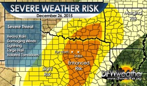
As discussed, a powerful storm system will be affecting the area for the next couple of days. This storm system will be responsible for a variety of weather across the state, including a historic blizzard in West Texas to heavy rainfall and severe weather in our area. The Storm Prediction Center has placed our entire forecast area in an enhanced risk area for severe weather. Abundant moisture, indicative of dewpoints well into the 60s, very warm temperatures well into the 70s, will create convective instability around 2000 J/Kg. Combined with adequate shear, approaching cold front, and destabilization from storm system, the parameters are in place for severe weather across our area. The main threats will likely be heavy rainfall, but damaging winds and large hail will also be possible. In any discrete storms that can become rooted in the boundary layer may be able to spin up an isolated tornado. Most of the convection will be tied to a strong Arctic cold front that will move across the area and force the convection to take on a linear storm mode which should lessen the tornado threat. The cold front should be around DFW in the 10:00 PM to 12:00 AM timeframe. Behind this front much colder air will spread into the region lessening the severe weather threat.
DFW Weather News and Blog

