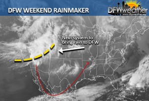
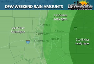
After a good reprieve from the excessive rainfall over the Thanksgiving Holidays, rain will return to North Texas this weekend. Rain chances will be highest on Saturday evening into Saturday night. The greatest threat for flash flooding will be along and east of the I-35 corridor where the heaviest rains fell last time. Grounds are still saturated from the last event, and coupled with the dormant vegetation, flash flooding will be a real concern. Instability with this system will be small with high shear, thus a rogue strong to severe storm cannot be ruled out.
A warm air advection pattern will continue through Saturday as southwest flow aloft prevails across the area out ahead of the storm system. This will advect moisture and ridiculously warm temperatures into our area. In fact, they will be downright hot for December. Highs on Friday may flirt with the record high at DFW which is 80°F set in 1938 and 1996. This will be highly dependent on cloud cover and moisture, thus the dfwweather.org forecast has officially kept highs just shy of the record. Overnight lows will be well above the normal high for early December Friday night (in the low to mid 60s) which is about 59°F. These temperatures are nearly 30 degrees above normal for this time of year. A Pacific cold front will push across the area Saturday night and this will be the main focus for shower and thunderstorm development. Some lingering rain showers behind the front may be possible on Sunday, especially if the slower ECMWF scenario pans out. Otherwise, temperatures will return to more seasonable levels behind the front with lows in the 40s and highs in the 50s.
It is too early to forecast rain amounts with the weekend system, but early indications are that amounts will generally be around an inch or less. It must be stressed, we are not expecting anywhere close to the amounts received over Thanksgiving.
We will be watching another storm system taking shape for next week that may bring even more rain to the area.


