Just a reminder that Daylight Savings Time ends early tomorrow morning (November 5, 2017) at 2:00 am, and we fall back one hour to Central Standard Time. Don’t forget to set your clocks accordingly.
Category Archives: News
DFW SHATTERS HIGH TEMPERATURE RECORDS
A record high temperature of 94°F was set at DFW Airport yesterday, November 2, 2017. This shatters the old daily record of 87°F set in 2012. In addition, this also breaks the record of the hottest temperature ever recorded during the month of November. The old monthly record was 89°F set on November 5, 2005. This also is the hottest temperature ever recorded at DFW so late in the year.
A BIT COOLER TOMORROW COMPARED TO TODAY’S RECORD HEAT
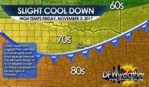
The latest forecast data is now showing a cold front, originally forecasted to stay north of North Texas, to penetrate into North Texas. The front may now even clear all of North Texas. What this means is that Friday will be cooler than originally forecasted with temperatures 10 to 15 degrees cooler than the record heat experienced today. Expect highs in the 70s tomorrow compared to the upper 80s to lower 90s today. The cooler weather won’t last long as the front will retreat northward as southerly flow strengthens. This will bring humidity levels back up and temperatures will soar back into the upper 80s for Saturday and Sunday. Another weak cold front may approach on Monday, but it will be little more than a wind shift line. The next strong cold front may not arrive until the middle or latter part of next week.
ALL TIME NOVEMBER RECORD HEAT EXPECTED TOMORROW AT DFW
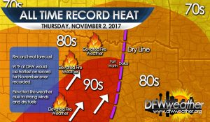
Temperatures are expected to soar into the 90s for portions of the forecast area tomorrow. Current forecast temperature at DFW Airport for tomorrow is 91°F. If this occurs, it will be the hottest temperature ever recorded for November and the hottest temperature ever recorded so late in the year. A dryline will sharpen out west and surge eastward bisecting the forecast area. Areas behind the dryline will experience a drop in humidity, strong southwesterly winds, and soaring temperatures. Since the recent bout for freezing temperatures, fuels have dried and cured. Combined with the low humidity and strong southwesterly winds, conditions will become critical for the starting and spreading of grass fires. Thus, an elevated fire weather risk will be possible the further west you go from the dryline. Areas east of the dryline will have higher humidity levels and temperatures will be held in the 80s.
IT IS THE COLDEST OCTOBER MORNING SINCE 1993 AT DFW
After an Arctic cold front blasted through the area early yesterday morning, it has been downright cold around DFW. This morning the temperature dropped to 34°F officially at DFW Airport. This makes this the coldest October morning since October 31, 1993 when the mercury hit 29°F with, believe it or not, a few snow flurries during that cold air outbreak. It also is the coldest we have been at DFW since January 27th of this year. Last year was the hottest winter on record for DFW, even though the coldest temperature of the winter did get to 14°F on January 7th. The prior winter (2015-2016) was also one of the warmest on record and had the warmest low ever recorded during a winter season of only 27°F. Here are some other low temperatures this morning from across the area:
- Fort Worth Alliance 27°F
- Fort Worth Meacham 35°F
- Fort Worth Spinks 28°F
- Arlington 29°F
- Dallas Love Field 34°F
- Denton 28°F
- Granbury 29°F
- Cleburne 28°F
- Decatur 32°F
- Grand Prairie 37°F
- Midlothian/Waxahatchie 31°F
HURRICANE IRMA NOT A THREAT TO THE TEXAS COAST
Hurricane Irma, still days away from making landfall on the continental United States, is not a threat to the Texas coast, despite the garbage being disseminated on social media. In fact, there is not a computer model forecast that takes Irma into the Texas coast. Irma will likely be our next major hurricane in the Atlantic basin possibly reaching Category 5 strength, but as stated, she is days away from reaching the United States. There is another area of disturbed weather coming off Mexico that may be a potential tropical threat for the Gulf in about 6 to 10 days. This may bear watching; however, we have a pretty stout cold front coming down the Plains next week that is expected to make it out into the Gulf. This front will effectively act as a barrier wall for Texas against the tropics. This front may bring a quick shot at rain as it barrels through North Texas Tuesday evening. Winds will turn out of the north around 20 mph or so and be quite breezy behind this front. Temperatures will feel more autumn like by Wednesday and Thursday of next week. Much of North Texas is expected to fall into the 50s by Thursday morning as much drier and cooler air is advected into the region.
UPDATE ON HURRICANE HARVEY
The latest information on Hurricane Harvey as of 9:00 am 8/25/2017 is:
Location: 26.5N 95.9W
About 130 miles or 205 km SE of Corpus Christi, TX
About 135 miles or 215 km SSE of Port O’Connor, TX
Sustained Winds: 110 mph or 175 km/h (Strong category 2 storm)
Movement: NW or 315° at 10 mph…17 km/h
Pressure: 948 mb
Latest forecast track from the National Hurricane Center has Harvey making landfall at 1:00 am Saturday morning with maximum sustained winds of 120 mph, which is a category 3 storm. Landfall is expected northeast of Corpus Christi, TX.
Impacts for the DFW area are expected to be quite minimal given the latest track of this storm. Cloud cover and some rain will be possible, but the heaviest rain and winds will be well southeast of our forecast area. Indirectly, since we will be on the subsident side of the storm with stronger northerly flow aloft, low temperatures may begin to benefit from that and drop into the 60s by early next week.
ALERT: HURRICANE HARVEY EXPECTED TO BE A MAJOR HURRICANE TO MAKE LANDFALL IN TEXAS
It has been more than 10 years since a major hurricane has made landfall on the United States coast. It was Hurricane Wilma in October of 2005. The last hurricane to affect Texas was category 2 Hurricane Ike in 2008, nearly 10 years ago. Harvey is now forecast by the National Hurricane Center to become a category 3 hurricane upon making landfall near Corpus Christi on the Texas coast. This makes Harvey a major hurricane. The latest storm information on Harvey as of 12:00 pm is:
TOTAL SOLAR ECLIPSE ON AUGUST 21, 2017
Much of the United States will experience a solar eclipse on August 21, 2017, including North Texas. However, North Texas will not be in the path of totality of this eclipse, thus they will not experience the total solar eclipse. The path of totality, the area where locations will be in the center of the moon’s shadow blocking the sun, will track in a narrow 70 mile wide strip across the states of Oregon, Idaho, Wyoming, Nebraska, Kansas, Missouri, Illinois, Kentucky, Tennessee, Georgia, North Carolina, and South Carolina. In this area, daylight will become as dark as night time. The eclipse is expected to begin at 10:15 am PDT (12:15 pm CDT) and end at 2:48 pm EDT (1:48 pm CDT). The eclipse will take about one hour and forty minutes to cross the nation.
A total solar eclipse occurs when the sun, moon, and the earth are in direct alignment. It is only viewable from earth in a rather small area. North Texas, again, will not be in that path, but will see a pretty good partial eclipse. Viewers of the solar eclipse should never look directly at the sun with the naked eye. Special viewing glasses must be worn to protect the eyes while viewing the eclipse to prevent permanent eye damage.
Please see the animation by NASA below for further details of the path of the upcoming eclipse. The next total solar eclipse viewable from the United States will occur on April 8, 2024. North Texas will be in the path of totality of the 2024 eclipse.
100 YEAR RECORD RAINFALL BROKEN YESTERDAY AND DFW OFFICIALLY REACHED 100°F FOR THE FIRST TIME THIS SUMMER LAST FRIDAY
Last Friday, June 23, 2017, DFW Airport’s high temperature hit 100°F for the first time this summer, thanks to compressional warming ahead of a rather strong late season cold front. This front was responsible for the overnight intense convection that occurred Friday night. By the end of the day Saturday, June 24, 2017, DFW broke a 100 year rainfall record. 3.84 inches of rain officially fell yesterday shattering the old record of 1.76 inches set in 1917. This brings the monthly June total of rainfall for 2017 to 7.93 inches.


