
As of today, November 5, 2015, DFW has failed to fall below 50°F. We will finally do so Sunday and Monday mornings, possibly as early as Saturday morning. This will make it the latest we have ever gone without falling below 50°F over 117 years of weather records (dating back to 1898).
Category Archives: News
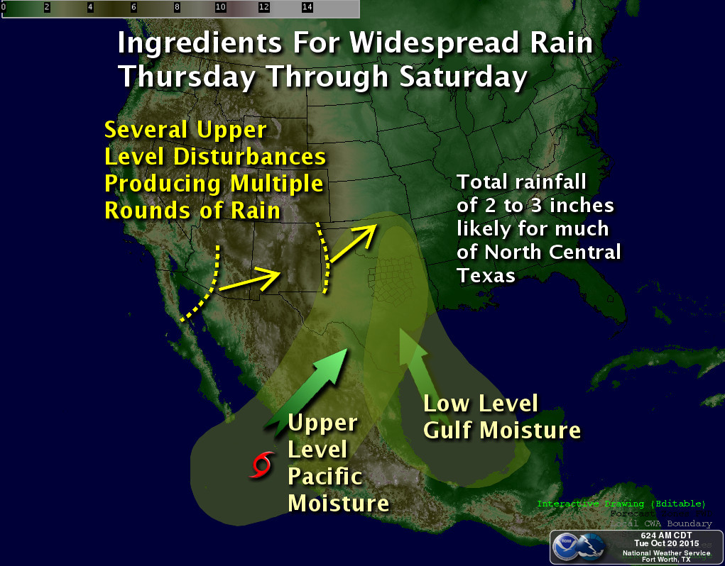
HEAVY RAIN POSSIBLE ON THURSDAY…LOWS IN THE 40s THIS WEEKEND
Our next storm system, that will affect our weather, is currently moving from down from the Pacific northwest. It will move as far south as Nevada before opening up and moving east across the Plains. Ahead of the upper-low, moisture will begin advecting into our area, indicative of the mostly cloudy skies today. Showers and thunderstorms will begin to overspread the area as early as tonight and become widespread on Thursday into Thursday night. There is some marginal instability with this system and very high shear, thus we cannot rule out one or two severe storms with moderately sized hail, but overall widespread severe weather is not expected with this system. However, PWATs are expected to climb to 2 inches by Thursday. This will allow for storms to produce heavy rainfall. So by far our biggest threat with this system will be heavy rainfall. Since our grounds are saturated and cannot hold anymore water, the National Weather Service in Fort Worth has already issued a Flash Flood Watch for nearly the entire forecast area. Widespread 1 to 2 inches look like a good bet with this system with isolated higher amounts.
A cold front will move across the area behind this system early Friday. This front will bring a little chill to the air as it has some Canadian air behind it. Thus, morning low temperatures are likely to dip into the 40s for the first time this year at DFW Airport over the weekend with highs struggling to make it into the 60s on Sunday. The models continue to hang back some energy for the weekend. Thus, after a dry day on Friday, low end POPs are warranted for Friday night into Saturday for some light rain in the cooler air.
We are watching another storm system for early next week that has the potential to bring more showers and thunderstorms to DFW. A stronger cold front may be on tap for later next week.
OCTOBER 2015 THE 2ND WETTEST OCTOBER ON RECORD
October 2015 has come in as the second wettest October on record. The top five wettest Octobers are:
- 1981 – 14.18 inches
- 2015 – 9.82 inches
- 1919 – 9.44 inches
- 1991 – 9.32 inches
- 1959 – 9.22 inches
This brings the total for the year 2015 to 48.93 inches of precipitation, making it, so far, the sixth wettest year in DFW weather records.
October 2015 came in with a mean average temperature of 71.2°F, making it the 12th hottest October on record. This puts the year 2015 so far in the running, with an annual average mean temperature of 69.3°F, as being the hottest year on record for DFW.
MAJOR RAIN EVENT TODAY TO SUNDAY [UPDATED]
Setup for major rain event unfolding for DFW for Thursday through Sunday. Map courtesy of the National Weather Service, Fort Worth, Texas.
UPDATE: It appears that everything is lined up for two episodes of heavy rain, one tonight into tomorrow, and another tomorrow night into much of Saturday. Forecast rain amounts, when all said and done, will be a widespread 3 to 6 inches of rain across the forecast area with isolated amounts approaching, or even exceeding, 10 inches. It is too hard to determine where the heavier, narrow bands of really intense rainfall will setup, or what areas will see the most training of storms, but these are the areas that will receive the most amounts of rain. A Flash Flood Watch has already been hoisted by the National Weather Service office in Fort Worth that includes all counties covered by this website. Please stay alert to changing weather conditions, and remember, don’t drive your car into flooded roadways.
It has been quite some time since DFW recorded multi-inch rains or had a protracted rain event, but it appears the ingredients are coming together for a major, protracted rain event later this week. An upper-level low is going to slowly eject east northeast from the desert southwest onto the plains. As it does so, tropical moisture gathering near the Yucatan (was once projected to form into a tropical system by the models, now will not) will be advecting northward into North Texas. In addition, what will be a named storm, Patricia in the Pacific, her remnants and moisture will get absorbed northward into Texas this weekend allowing pWATS to climb to 2 inches, a good two standard deviations above normal for October. Another disturbance will quickly move in on the heels of the desert southwest upper-low dragging a cold front with it providing additional lift Saturday and Sunday. All this points to a heavy, protracted rain event beginning as early as Thursday and lasting through Sunday for the forecast area. It is too early to nail down just how much rain we will receive, but indications are that this will be a widespread multi-inch rain event for the area.
DFW AIRPORT SETS NEW RECORD HIGH TEMPERATURE YESTERDAY, OCTOBER 15, 2015
The official climate site at DFW Airport set a new record high temperature yesterday, October 15, 2015. The mercury reached 95°F breaking the old record of 92°F for the date set in 1948 and 1999.
RECORD HEAT AGAIN TODAY AND TOMORROW AT DFW
The record high for DFW for today, October 14th is 99°F set in 1910. The record for tomorrow, October 15th is 92°F set in 1999. Forecasted temperatures are to be in the 97°F to 100°F range for today and tomorrow. Likely making both records in jeopardy. The hottest day will likely be today given the strength of the overhead ridge and the southwest/westerly downslope components to the winds. If we reach 100°F today, it will set an all time record for the latest DFW has ever hit the triple digits by a wide margin. That would truly be an incredible feat! Given that is almost a 40°F diurnal temperature difference (extremely rare for us), and more characteristic of a desert climate, means we will probably stay just under the century mark. Tomorrow should be a degree or so cooler as the upper ridge weakens a tad, but the record is only 92°F, and that is a certainty it will be broken, as forecasted highs will be in the upper 90s, yet again. A cold front is on tap for Friday, but given how dry we are ahead of it, it will not produce any rain. However, it will lower temperatures significantly over the weekend with lows in the low 50s and highs struggling to reach 80°F, making for a truly nice autumn weekend. A stronger trough and system looks promising for the middle of next week for the best rain chances in awhile and a more significant autumn cool down, but more on that later.
NEAR RECORD HEAT POSSIBLE NEXT SUNDAY AND MONDAY FOR DFW
The record high temperature for DFW for Sunday, October 11th is 99°F and for Monday, October 12th is 97°F. Current forecast models are predicting high temperatures approaching 100°F across the area on these dates. If temperatures were to actually hit 100°F at DFW, it would not only be the hottest temperature for these dates, but also the latest on record that we have ever hit the triple digits. Currently, the latest we have ever hit triple digits at DFW is 106°F set on October 3, 1951. Currently, it looks as though temperatures may stay just below the century mark on both dates, but records could be tied or threatened. This is definitely some hot October weather!
SEPTEMBER 2015 AMONG HOTTEST ON RECORD FOR DFW [UPDATED]
UPDATE: September 2015 is officially the 5th hottest September on record for DFW. The top 5 hottest Septembers are as follows:
- 2005/1939 – 83.7°F (average monthly temperature)
- 1998 – 83.6°F
- 1931 – 83.0°F
- 1933 – 82.8°F
- 2015 – 82.7°F
September 2015 is shaping up to be among the hottest Septembers on record for DFW. The hottest September occurred in 1939 and 2005 where the average temperature for the month reached 83.7°F. Currently, this month, so far, is third hottest with a current average temperature of 83.5°F. The second hottest September is 1998 with a monthly average temperature of 83.6°F. There is no indication of a significant cool down between now and the end of the month, thus 2015’s chances of remaining among the hottest Septembers on record is quite high. However, it isn’t likely for us breaking the 1939/2005 record, based on forecasts through the end of the month.
SUMMER HEAT TO MAKE A VALIANT COMEBACK THIS WEEK
Don’t get too comfortable with the brief early glimpse of fall that we experienced over the past weekend, where morning temperatures fell into the 50s and lower 60s across the forecast area on Sunday coupled with a dramatic decrease in humidity levels. Winds will abruptly and vigorously turn back to the south in response to a deepening low pressure system ejecting out of the Rockies onto the Northern Plains. This system will have little impact on our sensible weather, but the increase in southerly wind speeds will advect Gulf moisture back into the area. As temperatures warm back to and above seasonal normal values (89°F normal high for this time of year), heat index values will also soar back to above the century mark by the end of the week, thanks to the increase in humidity. A weak cold front will approach the area by the end of the week with perhaps a few spotty showers and thunderstorms along the Red River. This will be something to watch because if the front sinks farther south, then our chances locally increase for isolated showers and thunderstorms. Though the summer heat will try to make a valiant comeback, at this time, there does not appear to be any sign, aside from the heat index, of triple digit ambient air temperatures. Not too much longer to go before it will be impossible for triple digit heat to occur until next year. Thus, the clock is really winding down fast on summer…
SIGNS THE SEASONS ARE A CHANGING
A significant upper-air pattern change is going to take place this week across the CONUS that will have direct impacts on the sensible weather for North Texas. A series of shortwaves will carve out a substantial trough in the center of the CONUS this week, helping to break down the upper-ridge that is currently sitting on top of Texas over the holiday weekend. This ridge will ensure temperatures stay in the upper 90s to near 100°F through the middle of next week. The deepening trough and the dropping of the westerlies southward will help drive a significant cold front south into Texas by the last part of the week. This will increase rain chances for our area, bring in much cooler temperatures, and eventually drive drier continental air into the region. Behind the front, temperatures should plummet into the 80s for highs (possibly cooler depending on cloud cover and post-frontal precipitation) and into the low to mid 60s for overnight lows, especially after the effects of the drier continental air advects into the region. This is a sure sign the seasons are a changing!