Category Archives: Forecast Blog

FORECAST UPDATE: STORM THREAT DIMINISHES – DRYLINE THROUGH MUCH OF THE METROPLEX

Today’s thunderstorm chances are rapidly diminishing as storms march eastward along with the dryline and cold front close behind. Strong, westerly, downsloping winds are increasing behind the dryline  as the low pressure system deepens as it marches eastward across the central Plains. These strong downsloping winds will help temperatures soar to near record levels today. The record high temperature for today at DFW is 85°F set in 1911. Forecast highs were raised a bit after temperatures soared to the forecasted high of 83°F from this morning’s issuance. Winds will gust to near 35 mph behind the dryline making for a quite windy afternoon. Our winds will switch to the northwest this evening where they should decouple a bit after sunset. The much drier air will allow temperatures to cool efficiently this evening with overnight lows expected in the 40s area wide. We should be much cooler tomorrow with highs only reaching the mid to upper 60s.

We are still watching a southern stream system that could affect our weather as early as Saturday night with more chances of showers and thunderstorms, especially on Sunday and Monday. An even stronger system may be on tap for later next week.

AN ACTIVE PATTERN CONTINUES FOR DFW

A rather active weather pattern will continue through this week for DFW. Our next system to affect the area will arrive on Wednesday in the form of a Pacific cold front. The low pressure associated with this system will eject from the four corners region onto the Central Plains rather quickly. Scattered showers and a few thunderstorms will be able to form in the warm air advection pattern out ahead of this system as early as Tuesday night. However, our best chances for rain will come Wednesday morning with the passage of the cold front. At this time, given the timing of this system, speed, and lack of instability aloft, severe weather is not expected for the immediate DFW Metroplex. Rain amounts will be rather limited as well given the speed of the system. Winds behind the cold front will be quite strong bringing much drier air into the region. Winds could gust in the 30 to 40 mph range on Wednesday afternoon. The cool air associated with this frontal passage will not actually truly be felt until Wednesday night into Thursday morning where overnight lows will drop into the low to mid 40s area wide.

Another system will approach the area by next weekend brining our next bout of rain, especially on Sunday. This system may become detached from the mean flow and be a less progressive system.

There is still no indication of any truly cold air or freezes coming our way, at least not in the next ten days.

PATTERN CHANGE TO BRING RARE SUMMERTIME COLD FRONT TO DFW

The synoptic, upper-air pattern will begin a change today. Amplified ridging will build along the west coast of the United States and deep troughing will ensue across the eastern 2/3 of the CONUS. This will allow a Canadian airmass to dive south into Texas over the weekend. The cold front should approach the Red River counties of North Texas by tomorrow afternoon. Compressional warming ahead of the front will allow for temperatures to climb into the upper 90s as far south as the I-20 corridor for highs on Friday. Showers and thunderstorms will break out along the front. Rain chances will spread form north to south as the front progresses south. This is not expected to be a heavy rain event as it will be relatively short in duration as the front passes. Behind the front, much drier and subsident continental air will spread in as the surface high builds southward. Temperatures will be a good 8 to 12 degrees cooler behind the front with highs in the 80s and lows in the mid-to-upper 60s. Not bad for June in Texas!

RAIN CHANCES RETURN TO DFW WITH WARMING TEMPS

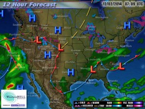
Current weather map for December 2, 2014, courtesy of WeatherBell.

Current weather map for December 2, 2014, courtesy of WeatherBell.

The Arctic airmass that has settled across DFW and the rest of North Texas on Monday will begin to erode, as the Arctic high slides east and a rather intense warm air advection pattern begins. Our winds will become south/southwesterly today and back more south/southeasterly tonight. This will allow warmer air to begin overriding the colder air at the surface. Well after midnight tonight, areas of fog and drizzle will begin to develop across the forecast area. Some of the fog could be rather dense at times with visibilities below 1 mile.  The fog and drizzle will be very slow to burn off on Wednesday and will hang in for much of the morning. Given the pattern, we will keep low chances of light rain showers in the forecast through Friday. Temperatures will begin to warm to near normal, or slightly above, (60s/70s) as we head into the middle and latter part of the week.

By Friday, rain chances will increase as a shortwave  approaches (courtesy of weakening upper low moving ashore off the California and Oregon coast) in conjunction with a cold front from the north. Widespread rain will be possible with isolated thunder as dynamics increase ahead of this system. The cold front is expected to move across Friday evening with a combination of Pacific and Canadian air. This front will not be nearly as strong as the Arctic front that moved through early Monday morning. However, it will keep temperatures below normal heading into early next week as another stronger disturbance and cold front arrives. This will bring additional rain chances to the region as we head into next week.

DFW RAINFALL AMOUNT TOTALS AND THANKSGIVING WEEK OVERVIEW

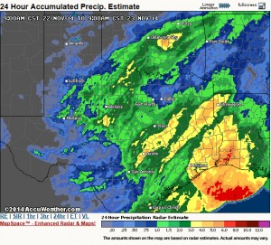
The storm system that brought much needed rainfall to DFW has pushed over to the northeast. In its wake, skies were clear with some patchy fog in some locations which should quickly burn off this morning. Rainfall totals were less than what we forecasted as the system took a much further south track than we thought. However, we did get much needed rainfall across the area, but not everyone saw over an inch of rain as we had hoped with our western and southern counties seeing the most precipitation. Please see the pic for a radar estimate of storm totals.

Radar estimate of rainfall totals over the last 24 hours. Courtesy of Accuweather.

Radar estimate of rainfall totals over the last 24 hours. Courtesy of Accuweather.

Another deepening storm system in Colorado will tighten the pressure gradient causing our winds to pick up out of the west today and become quite gusty out ahead of a cold front. High temperatures are going to be very tricky today as compression warming from the front and westerly component to the wind will support a substantial warm-up in the upper 70s. However, the ground is still very wet and will help to offset the warming a bit. Therefore, the official DFW Weather forecast went with the cooler guidance number for highs today in the middle 70s.

The cold front will bring temperatures down a good 15 degrees tomorrow with more seasonable weather. This will setup a beautiful Thanksgiving week for North Texas with seasonal weather. Computer model guidance is showing temperatures rebounding well into the 70s for the Thanksgiving weekend. Last week, it looked like we were going to get another surge of Arctic air, but over the weekend, the models back off this scenario. While here at DFW Weather, we are going for the warmer weather scenario for the official forecast, this forecaster will caution that Arctic air is damming up on the models in Oklahoma and Texas Panhandles. In this type of situation, usually the cold air wins out, and we do get a some sort of frontal passage. This is due, in part, to the fact that cold air is very dense and tends to sink south against the mean flow, and to the fact that models have a hard time in general with placement of shallow/dense-low level cold air. This is something to definitely watch, and the forecast could change drastically next weekend.

LATEST FORECASTED RAIN TOTALS FOR DFW THROUGH SUNDAY

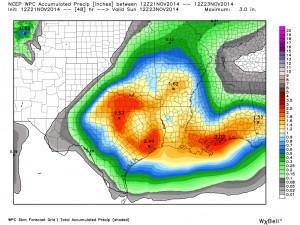
Our big storm system is on its way. The system is now onshore over California and will be moving over North Texas tomorrow. This continues to look like a widespread, mult-inch rain event for the DFW area. 2 plus inches of rain is possible, especially from the DFW Metroplex north and west toward the Red River counties with isolated amounts up to 4 inches in some of the heavier downpours. The data continues to suggest the severe weather threat will remain well south and east of the Metroplex; although, it is still possible that one or two strong storms cannot be entirely ruled out in our area.

Weather Prediction Service of expected rainfall totals across the Sate. Data courtesy of WeatherBell.

Weather Prediction Center of expected rainfall totals across the Sate. Data courtesy of WeatherBell.

The biggest concern will be the potential for heavy rainfall in our area as pWATS (precipitable water) levels increase to 1.50 inches. Well above normal for this time of year. We are still in extreme drought conditions, thus runoff will be absorbed well by area lakes and area soils very dry. Therefore, widespread flooding is not a concern, though localized, urban flash-flooding will be possible.