Category Archives: Forecast Blog

SIGNIFICANT SEVERE WEATHER OUTBREAK EXPECTED TODAY LATE AFTERNOON WELL INTO THE EVENING

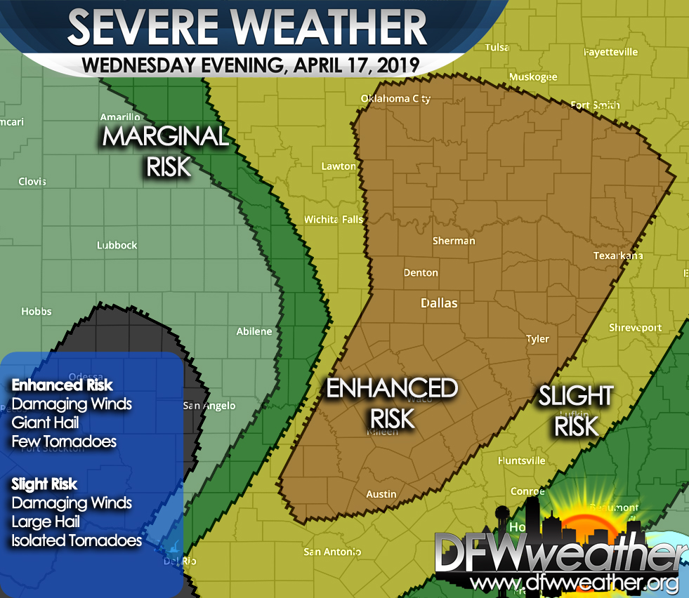
A potentially significant severe weather episode is unfolding for the forecast area later this afternoon well into this evening. The Storm Prediction Center has placed the entire forecast area in the Enhanced Risk category for severe weather. Please see the map below. The Enhanced Risk area is in orange, the Slight Risk area is in yellow, the Marginal Risk area is in dark green, the lighter green area means non-severe convection is possible.

Setup: A powerful upper level trough will be digging into the western portions of the state. A dryline will setup ahead of this system and begin surging eastward. Copious moisture advection from the Gulf will be pulled northward, indicative of dewpoints surging into the upper 60s/70s. CAPE (convective available potential energy) values in this moisture laden, warm atmosphere will climb to around 3000 to 3500 J/Kg with shear in excess of 50 knots.

What to Expect: Discrete cells should begin firing along and ahead of the dryline and possibly as far east as the I-35 corridor late this afternoon. These will rapidly become severe producing gigantic sized hail in the Enhanced Risk area. It will be possible for hail to reach baseball, or even softball, size in this type of environment. Over time these cells should grow into a QLCS (quasi-linear convective system) and push eastward with an attendant damaging straight-line wind threat. With the discrete supercells, especially ahead of the dryline, a few tornadoes cannot be ruled out. The tornado threat should wane as the storms form into QLCS. Another line of storms may approach the area later tonight along the actual cold front.

When: Wednesday, April 17, 2019 between 5:00pm and Midnight.

Please stay alert to changing weather conditions and heed any possible warnings that may be issued for your location.


Storm Prediction Center severe weather outlook for Wednesday, April 17, 2019. Damaging winds, giant hail, and a few tornadoes are possible in the Enhanced Risk area which covers the entire forecast area.

RAIN RETURNS TO DFW

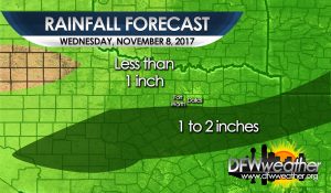
A cold front has moved through the entire forecast area. Moist flow running atop the cooler air at the surface has led to cloudy skies today. A disturbance will be approaching the region tonight from out west spreading lift across the area. PWATs (precipitable water) values are expected to climb to 1 to 1.5 inches across the area. This will lead to numerous showers to develop tonight into tomorrow night. This is not expected to be a widespread heavy rain event as all precipitation is expected to be light to moderate. Rainfall amounts will vary from as little as .10″ to just over an inch in the immediate DFW Metroplex. Heaviest totals will be to the south and east of the Metroplex. Precipitation is expected to end from west to east Wednesday night. Cold air advection, clouds, and rain will keep temperatures in the 40s all day tomorrow. Lows will drop into the upper 30s and lower 40s for Thursday morning. Another cold front with more shots at rain is expected this weekend.

Forecast rainfall totals for Wednesday, November 8, 2017

HURRICANE IRMA NOT A THREAT TO THE TEXAS COAST

Hurricane Irma, still days away from making landfall on the continental United States, is not a threat to the Texas coast, despite the garbage being disseminated on social media. In fact, there is not a computer model forecast that takes Irma into the Texas coast. Irma will likely be our next major hurricane in the Atlantic basin possibly reaching Category 5 strength, but as stated, she is days away from reaching the United States. There is another area of disturbed weather coming off Mexico that may be a potential tropical threat for the Gulf in about 6 to 10 days. This may bear watching; however, we have a pretty stout cold front coming down the Plains next week that is expected to make it out into the Gulf. This front will effectively act as a barrier wall for Texas against the tropics. This front may bring a quick shot at rain as it barrels through North Texas Tuesday evening. Winds will turn out of the north around 20 mph or so and be quite breezy behind this front. Temperatures will feel more autumn like by Wednesday and Thursday of next week. Much of North Texas is expected to fall into the 50s by Thursday morning as much drier and cooler air is advected into the region.

DFW SETS ANOTHER RECORD HIGH YESTERDAY, FEBRUARY 23, 2017 / 2017 HOTTEST FEBRUARY / 2016-17 HOTTEST WINTER

DFW high temperature yesterday, officially at DFW Airport, was 88°F. This breaks the old record of 86°F set in 1933.

This also adds to the record number of 80+ degree days set in any winter. 2016-2017 is the winter with the most 80+ degree days currently at 12. The old record was 10 set in the 2005-2006 and 1908-1909 winter seasons.

*February, with only 4 days left in the month, is on target to be the hottest February in DFW history with an average mean temperature so far of 60.7°F. This shatters the old record of 58.4°F set in 1976.

*The winter of 2016-2017 is also set to be the hottest winter on record for DFW (as measured December 1st through February 28th) with a mean average temperature of 53.9°F. This breaks the old record of 53.1°F set in the 1999-2000 winter.

* Given the forecast through the end of February, these statistics will likely hold, but the final averages may change slightly.

RECORD HIGH TIED YESTERDAY JANUARY 10, 2017 AT DFW

The record of 79°F set in 1995 was tied yesterday, January 10, 2017, at DFW Airport. The high temperature reached 79°F yesterday afternoon, despite a weak cold front moving through the area. That front will retreat north today putting us back in the warm sector again today. High temperatures today will be flirting in record territory. The record for January 11th is 83°F set in 1911, and the forecasted high is 81°F.

COLDEST SINCE 2011 FOR DFW THIS PAST WEEKEND

This past weekend’s Arctic air outbreak left us the coldest DFW has been since 2011. The low temperature of 14°F on Saturday, January 7, 2017 was the coldest since February 2, 2011 when the mercury hit 13°F. The high temperature of 27°F on Friday, January 6, 2017 was a record low maximum temperature for that date which broke the old record low maximum temperature of 29°F set in 1970. The cold air over the weekend was the coldest outbreak of cold air for the nation as a whole since 1996. There was 0.10 of an inch of snowfall officially recorded at DFW Airport on Friday, January 6, 2017, nearly all of which remained on the ground on Saturday, January 7, 2017.

DFW HEADED BACK TO THE DEEP FREEZE THIS WEEKEND

While it feels cold outside this morning with temperatures in the 30s, wind, and patchy areas of drizzle, it will be nothing compared to what is coming this weekend. Today will struggle to warm under mostly cloudy skies with temperatures topping out in the mid 40s. A rapid warm-up will commence tonight as an intense warm air advection pattern unfolds out ahead of the next trough. Temperatures will actually start out colder and warm steadily through the night. Actual lows for tomorrow will probably occur closer to midnight than sunrise.

Warming will continue to take place through tomorrow as temperatures soar into the 70s. This will be short lived as powerful Arctic air mass is dislodged and plunges deep into Texas on Saturday. Timing of the front is somewhat hard to ascertain as these Arctic air masses always move faster than guidance. The current thinking is that the front will arrive sometime around midday Saturday. Temperatures should be able to warm into the 60s ahead of the boundary, possibly warmer if the front’s timing is later. Then there should be a drastic temperature drop behind the front. Guidance continues to trend colder with this air mass, and DFW Weather now is forecasting lows in the teens both Sunday and Monday mornings. Highs will struggle to get out of the 20s on Sunday, if at all, even under full insolation. It will also be windy with gusts to 35 mph possible. This will be put wind chill values in the single digits Sunday morning with wind chill values close to zero or below near the Red River. Wind chill values will remain in the single digits and teens throughout all of Sunday.

On Monday, temps will struggle to reach freezing, if at all, again making for another very cold day. Another cold night can be expected on Tuesday with morning temps bottoming out in the lower 20s once again.

Regarding the potential for wintry precipitation, it is looking much too dry at the surface and in the dendritic growth zone for snow crystal production. However, with these cold air masses, we cannot entirely rule out some patchy freezing drizzle or a flurry or two, but nothing significant. This is mostly likely to occur Saturday night early Sunday morning before the moisture is really scoured out, though most will see nothing.

Residents of the DFW area should prepare now for a prolonged period of subfreezing temperatures by winterizing their homes (wrapping pipes) and taking necessary precautions for outdoor animals and sensitive plants.

A WET WEEKEND FOLLOWED BY A BIG BLAST OF ARCTIC AIR MID NEXT WEEK

Get ready for a wet weekend followed by a substantial blast of Arctic air by next Wednesday. An upper-level storm system, deepening out west, will become a cut-off upper-level low over Mexico before lifting northeastward on Monday. At the surface, a reinforcing shot of colder air will spill southward. This will make for a wet, chilly, day on Saturday with temperatures likely not getting out of the 40s all day. Combined with northeasterly winds of 15 to 25 mph, wind chills will likely be in the upper 30s at times. Persons attending any outdoor sporting events will need to be prepared for wet and cold weather. This upper-storm system is already spreading moisture northward into Texas today. This will set the stage for a widespread rain event beginning as early as later this afternoon/evening and lasting through Monday.

The heaviest rains will come later tonight into Saturday as the first disturbance moves northeastward from this system. At this time, very little convection is expected, though we cannot entirely rule out a lightning strike. No severe weather is expected with this system. Rains may taper off a bit Saturday night into a good portion of Sunday, though some patchy drizzle/mist cannot entirely ruled out during this time frame. Rain chances will increase again on Sunday night into Monday as the main upper-low traverses over North Texas. This will bring the best chances at seeing convection. Widespread rain totals of 1 to 3 inches can be expected across the forecast areas with the heaviest totals off to the southeast.

After this system passes off to the northeast, our attention will turn to the north as the Arctic gates swing wide open. A very intense Arctic air mass will plunge southward reaching North Texas sometime on Wednesday. The front’s timing is still uncertain this far out. Very cold air will spill southward from eastern Alaska and the western Northwest Territories seeded from air originating from Siberia. Some models are going to a full blown McFarland look to the upper air pattern and driving the surface front as far south as Central America. This will definitely be colder than anything experienced last winter. There is no evidence that suggests any ice or snow with this Arctic intrusion as it looks quite dry. This portion of the forecast will continue to be refined as more data becomes available.


COLD AIR TO FINALLY ARRIVE IN NORTH TEXAS

So far this fall it has been exceptionally warm, but things are about to change as a major cold front is expected by Thursday night. For those wondering where all the cold air has been, some of it is about to arrive as the coldest air so far this season invades North Texas. The cold air has been locked up on the other side of the globe across much of Russia and Europe. In parts of Russia, temperature departures have been running as much as 50 below normal. Global signals have been pointing to a northern hemispheric pattern change for about the last ten days or so and the beginning will be occurring later this week.

Until the cold air arrives, near record breaking heat will be possible, especially tomorrow where temperatures may sore into the mid and upper 80s for highs. As a strong upper storm system digs along the west coast, southwesterly flow aloft and southerly flow at the surface will help bring up Gulf moisture into the area beginning tomorrow into Thursday. As the storm system begins pushing out onto the Plains, height falls will overspread North Texas allowing the pressure gradient to tighten making for a very windy day Thursday with gusts up to 35 mph possible. A strong cold front will push southward on Thursday night. As it does so, an initial EML will give way some scattered showers and thunderstorm development along the boundary as it pushes through the area Thursday night into early Friday morning. Not everyone will get rain, and the further east one goes across the forecast area, the better the rain chances.

Behind the cold front, expect much cooler/colder air will invade the area. Friday will see the high temperatures probably earlier in the day with near steady to slowly falling temperatures throughout the day. Lows by Saturday morning will for sure fall into the 40s area wide and highs on Saturday will struggle to reach 60°F, even under full insolation. By Sunday morning, the high pressure cell will build directly overhead into North Texas allowing for clear skies and an excellent radiational cooling setup. Lows should drop into the 30s area wide with some of the colder spots reaching freezing. The first frost of the season looks like a good bet for much of the area on Sunday morning.

FIRST DAY OF AUTUMN TODAY – BIG CHANGES ON THE HORIZON

UPDATE: The forecast below is largely unchanged. For this update though, the frontal timing will be adjusted a bit to reflect the latest data. The front is now expected to move across the DFW Metroplex on Sunday in the late morning to early afternoon timeframe as opposed to Sunday night. We are still expecting a decent rain event into early next week, with rain chances now extending into Tuesday. There should be widespread totals by Monday of 1 to 3 inches of rain with locally higher amounts possible.

Although today is the autumnal equinox, it will still feel like summer with above normal temperatures with highs well into the 90s continuing today. Though, we should thankfully not see any more triple digit heat like earlier this week. However, there are some big changes coming our way.

  • Moisture will begin to increase tonight in response to storm system forming out west.
  • Showers and thunderstorms will be on the increase tomorrow, mostly along and south of I-20, in response to the storm system moving out of the Rockies onto the Plains.
  • Showers and thunderstorms become more widespread on Saturday through Sunday.
  • PWATs increase to 2+ standard deviations above normal, setting the stage for bouts of heavy rain Saturday night through Sunday.
  • Strong cold front expected to arrive Sunday night (though timing could change). This will be the first significant cold front of the fall season.
  • Discrepancies between the ECMWF and GFS models, with the former cutting off energy and hanging it back, dictate when precipitation will shut off, regardless substantially drier and much cooler air will move in behind the cold front. Rain may linger into Monday per ECMWF which may effect degree of cooling of temperatures.
  • Widespread 1 to 3 inches of rain expected by Monday with locally higher amounts possible.
  • Temperatures behind the front should cool to the 50s in many areas for the first time this season with highs in the 70s.

The forecast could obviously change given the discrepancies among the ECMWF and GFS, especially with ending of rain and amount of cooling of the temperatures behind the front. Overall, the theme of a wet weekend and much cooler weather early next week is looking likely no matter which solution verifies.