Author Archives: dfwwea5

APRIL 2018 THE 6TH COLDEST AND 7TH DRIEST ON RECORD

From the National Weather Service in Fort Worth, Texas:

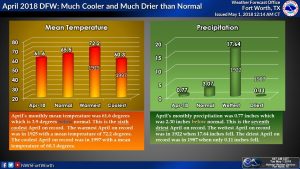
April 2018 was much cooler and much drier than normal at DFW. This was the 6th coolest and the 7th driest April on record. The monthly mean temperature was 61.6 degrees which was 3.9 degrees below normal. The mean high temperature for April was 74.4 degrees which tied for the 36th coolest and the mean low temperature was 48.9 degrees which was the coolest on record. DFW only received 0.77 inches of rain which was the 7th driest on record. Only 1987 (0.11″), 1920 (0.51″), 2005 (0.56″), 1937 (0.58″) and 1903 and 1983 (both 0.59″) were drier.


WEBSITE UPDATED TO INCLUDE CURRENT OBSERVATIONS

A new feature has been added to the website. On the left-hand navigation bar, a new link has been added called “Observations” found just below “News/Blog.” When you click on this link, you will be directed to a page that lists the current conditions from many of the major cities located within the forecast area covered by this website. Eventually, we hope to expand this features to list current observations across the state of Texas.

REMINDER: DAYLIGHT SAVINGS TIME BEGINS TOMORROW

Just a reminder that we spring forward one hour at 2:00 am tomorrow (March 11, 2018) as daylight savings time (CDT) begins. Remember to set your clocks ahead one hour. This means we do lose an hour of sleep, but we gain an hour of daylight at the end of the day.

DFW SHATTERS PRECIPITATION RECORDS FEBRUARY 28, 2018

4.72 inches of rain was officially recorded at DFW Airport on February 28, 2018. This makes February 2018 the wettest February on record at DFW Airport (11.31 inches recorded for the month) shattering the old record of 7.40 inches in February 1997. It also makes the 2017-2018 winter tied with 1931-32 winter for the wettest winter on record for DFW. It is also the most rain recorded on any single day during the month of February. It also shattered the daily rain record for February 28th, which was previously 0.92 inches set in 2001.

BITTERLY COLD NEW YEAR’S FOR DFW

A major Arctic air outbreak is expected to affect the area over the New Year’s holiday. An Arctic cold front will push south across the area on Saturday. There could be quite the temperature gradient from north to south as the front traverses the region. As the cold air filters into the region, what moisture is available in the atmosphere (not much) will be squeezed out as cold air cannot hold moisture. This will likely materialize in pockets of very light rain or drizzle from Saturday into Sunday. As temperatures drop below freezing Saturday night and Sunday morning, the drizzle will begin freezing to surfaces, possibly becoming mixed with sleet and/or snow grains as the cold air deepens. This is not expected to be a significant ice event for the area, but Sunday could have some travel spots on roads, especially bridges and overpasses. People with plans on New Year’s Eve should stay alert to the changing forecast conditions.

The cold air will deepen dramatically on Sunday with drier air filtering in from north to south effectively ending all precipitation. Strong and gusty winds will help sublimate any ice accretion rather rapidly. The cold will become the main story for much of next week. Once we drop below freezing on Sunday, we are not expected to get above freezing until Wednesday. Residents need to prepare now for 48+ hours of potential subfreezing weather. Lows New Year’s morning will be in the teens with wind chills in the single digits. People with plans New Year’s night will want to dress for the cold conditions. Highs will be in the 20s New Year’s Day and low 30s on Tuesday (still below freezing). The cold is expected to keep temperatures well below normal into Friday of next week.

RAIN RETURNS TO DFW

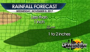
A cold front has moved through the entire forecast area. Moist flow running atop the cooler air at the surface has led to cloudy skies today. A disturbance will be approaching the region tonight from out west spreading lift across the area. PWATs (precipitable water) values are expected to climb to 1 to 1.5 inches across the area. This will lead to numerous showers to develop tonight into tomorrow night. This is not expected to be a widespread heavy rain event as all precipitation is expected to be light to moderate. Rainfall amounts will vary from as little as .10″ to just over an inch in the immediate DFW Metroplex. Heaviest totals will be to the south and east of the Metroplex. Precipitation is expected to end from west to east Wednesday night. Cold air advection, clouds, and rain will keep temperatures in the 40s all day tomorrow. Lows will drop into the upper 30s and lower 40s for Thursday morning. Another cold front with more shots at rain is expected this weekend.

Forecast rainfall totals for Wednesday, November 8, 2017

AGAIN DFW SMASHES ANOTHER RECORD HIGH, TIES ALL TIME RECORD FOR NOVEMBER

Yesterday, November 5, 2017, DFW smashed another record high. The temperature reached 94°F at DFW Airport. This smashes the old daily record of 89°F set in 2005. This also ties the all time November record set on November 2, 2017 of 94°F. This is also the hottest temperature ever recorded so late in the year at DFW. This is unprecedented record heat we have been experiencing lately (that we know about) out of nearly 120 years of weather records.