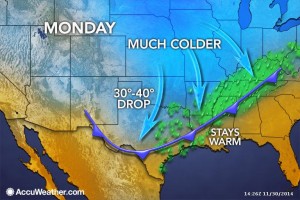
Residents of DFW should get out and enjoy the weekend, as it will be nice and warm for late November with temperatures pushing 80°F. All of this nice weather comes to an abrupt halt early on Monday as an Arctic cold front blasts through the area. Expect temperatures to be a good 35 to 40 degrees colder Monday and Tuesday from high temperatures experienced over the weekend. This Arctic airmass will be rather shallow as we are not expected to take the full brunt of the cold. It will stay to the north and slide off to the east rather quickly. This will make this Arctic blast rather short-lived, especially compared to the last one (not the same setup). By Wednesday, temperatures will be rebounding rapidly in a strong warm air advection pattern. The cold air will enhance lift across the area on Monday, thus low clouds and patchy drizzle will be the result. Areas northwest of the Metroplex may fall below freezing while the drizzle is falling, but impacts are not expected as extremely dry air in the upper levels should quickly shut off the drizzle. Lows by Tuesday morning should be below freezing area wide, probably in the 20s.
Author Archives: dfwwea5
THANKSGIVING DAY HISTORICAL SIGNIFICANT WEATHER EVENTS FOR DFW
- November 22, 2007 – A light wintry mix of sleet and snow fell during a cold afternoon. It was only the second occasion that wintry precipitation fell during a home Dallas Cowboys football game (vs. New York Jets).
- November 25, 1993 – Freezing rain and sleet fell during a subfreezing afternoon, amounting to 0.3″ on the ground. This was the first time that wintry precipitation was ever recorded on Thanksgiving. The low was 23°F and the high was only 35°F, making it the coldest Thanksgiving ever. Also, the annual Thanksgiving Day Dallas Cowboys football game (vs. Miami Dolphins) was the first time wintry precipitation fell during an NFL game in Dallas.
- November 25, 1965 – This hot day reached a record high of 88°F.
- November 22, 1945 – It was the first killing frost of the winter of 1945-46, a low temperature of 31°F.
- November 30, 1905 – The first killing frost of the season was a hard freeze, a morning low of 23°F.
DFW AREA LAKE LEVEL RISE SINCE WEEKEND RAIN EVENT
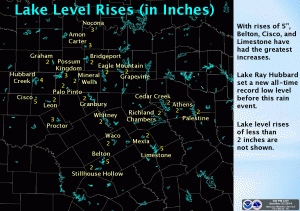
The system over the weekend brought much needed rainfall to the area. Many of the area lakes benefited from the rain. Below is a map showing the area lakes and how much of a rise they gained after the event. Belton, Cisco, and Limestone all showed the greatest gains with 5 inch increases. Lake Ray Hubbard set a new all-time record low level just before the rain event.
DFW RAINFALL AMOUNT TOTALS AND THANKSGIVING WEEK OVERVIEW
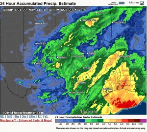
The storm system that brought much needed rainfall to DFW has pushed over to the northeast. In its wake, skies were clear with some patchy fog in some locations which should quickly burn off this morning. Rainfall totals were less than what we forecasted as the system took a much further south track than we thought. However, we did get much needed rainfall across the area, but not everyone saw over an inch of rain as we had hoped with our western and southern counties seeing the most precipitation. Please see the pic for a radar estimate of storm totals.
Another deepening storm system in Colorado will tighten the pressure gradient causing our winds to pick up out of the west today and become quite gusty out ahead of a cold front. High temperatures are going to be very tricky today as compression warming from the front and westerly component to the wind will support a substantial warm-up in the upper 70s. However, the ground is still very wet and will help to offset the warming a bit. Therefore, the official DFW Weather forecast went with the cooler guidance number for highs today in the middle 70s.
The cold front will bring temperatures down a good 15 degrees tomorrow with more seasonable weather. This will setup a beautiful Thanksgiving week for North Texas with seasonal weather. Computer model guidance is showing temperatures rebounding well into the 70s for the Thanksgiving weekend. Last week, it looked like we were going to get another surge of Arctic air, but over the weekend, the models back off this scenario. While here at DFW Weather, we are going for the warmer weather scenario for the official forecast, this forecaster will caution that Arctic air is damming up on the models in Oklahoma and Texas Panhandles. In this type of situation, usually the cold air wins out, and we do get a some sort of frontal passage. This is due, in part, to the fact that cold air is very dense and tends to sink south against the mean flow, and to the fact that models have a hard time in general with placement of shallow/dense-low level cold air. This is something to definitely watch, and the forecast could change drastically next weekend.
LATEST FORECASTED RAIN TOTALS FOR DFW THROUGH SUNDAY
Our big storm system is on its way. The system is now onshore over California and will be moving over North Texas tomorrow. This continues to look like a widespread, mult-inch rain event for the DFW area. 2 plus inches of rain is possible, especially from the DFW Metroplex north and west toward the Red River counties with isolated amounts up to 4 inches in some of the heavier downpours. The data continues to suggest the severe weather threat will remain well south and east of the Metroplex; although, it is still possible that one or two strong storms cannot be entirely ruled out in our area.
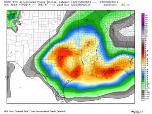
Weather Prediction Center of expected rainfall totals across the Sate. Data courtesy of WeatherBell.
The biggest concern will be the potential for heavy rainfall in our area as pWATS (precipitable water) levels increase to 1.50 inches. Well above normal for this time of year. We are still in extreme drought conditions, thus runoff will be absorbed well by area lakes and area soils very dry. Therefore, widespread flooding is not a concern, though localized, urban flash-flooding will be possible.
UPDATE ON MAJOR RAIN EVENT FOR FRIDAY AND SATURDAY
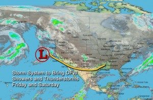
A big storm system, currently located a few hundred miles off the coast of Oregon and northern California (see pic), will be our next weather maker here in DFW. This storm system promises to bring much needed rainfall to the region. Latest data continues to suggest this to be a multi-inch rain event beginning late tonight in our northwest counties through Sunday.
Areas from the DFW Metroplex northward to the Red River counties stand the best chance to see 2 to 4 inches (with isolated higher amounts) of rain with this system by Sunday, as locally heavy rainfall will be possible in some of the storms. Flash flooding may not be widespread due to drier soils, but local flash flooding will be possible in the heavier downpours. As the system crosses the forecast area, the associated trough will become negatively tilted (one of the strongest weather system types) which will inhibit a capping inversion aloft. This will allow for surface-based convection with increasing instability leading to the potential for severe thunderstorms out ahead of the trough. Large hail, damaging winds, and tornadoes will all be possible with this severe weather threat. While one or two strong to severe thunderstorms cannot be entirely ruled out in the DFW area, the latest data continues to suggest that the best severe weather threat still looks to be south and east of the DFW Metroplex.
WARMING TEMPS AND MAJOR RAIN EVENT FOR FRIDAY/SATURDAY
We are finally beginning to warm up as the Arctic high releases its grip over North Texas. The Arctic high and trough are moving east allowing our winds to turn around to the south. This will advect warmer air and moisture into the area. You will be noticing warmer temperatures beginning today, with forecasted highs in the 60s and even warmer tomorrow as we climb into the mid-to-upper 60s. By Friday, a strong system will approach DFW in the southern jet enhancing moisture advection out ahead of the system.
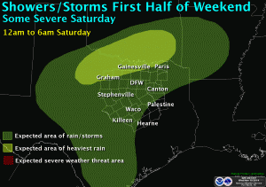
Animation of rain event expected over the forecast area Friday through Saturday. Courtesy of the National Weather Service office in Fort Worth, Texas. Click on the image for the full animation.
This will set the stage for numerous showers and thunderstorms, beginning as early as Thursday night in our northwest counties and area wide on Friday. Some of the showers and storms could produce heavy rainfall, especially on Saturday. Strong to severe weather will also be possible by Saturday, but mainly south and east of the forecast area. This is looking like it could be a multi-inch rain event for the area; however, it is much too soon to pinpoint rainfall amounts. As we get within 24 hours of the event, better data arrives and we will be able to determine more precise rainfall amounts. This is good news as the area does desperately need rainfall.
Don’t get too comfortable with the warmer temps as a cold front arrives on Sunday knocking our temperatures back down. This cold front will not be near as cold as the ones last week. However, things are beginning to come together for another Arctic blast over Thanksgiving weekend. More on that later . . .
NEW FEATURE—DFW WEATHER BLOG/NEWS PAGE
The news section will be condensed to recent news and blog headlines only. The full news and blogs articles will be posted on the new “News/Blogs” page. The link to this page is on the left menu navigation panel. The headlines appearing in this box will be hyperlinked to this page as well. In addition to weather news, there will be blog posts from time to time on the weather. All of the news and blogs will be archived.
RECORD SNOWFALL AND RECORD LOW MAXIMUM TEMPERATURE AT DFW
There was a trace of snowfall yesterday, Sunday, November 16th, at Dallas/Fort Worth International Airport. This is the first time in the 117 years that records have been kept at the official Dallas/Fort Worth site that it has snowed on November 16th.
Since records began for the official Dallas/Fort Worth site back in 1898, there have been 9 days of the month of November that have never reported snow: November 1st, 4th, 5th, 6th, 7th, 10th, 12th, 17th, and 18th.
The all-time record snowfall for any November day stands at 5.0 inches set on November 22, 1937.
The high temperature Sunday, November 16th at Dallas/Fort Worth International Airport was 40°F. This ties the record coldest high temperature for November 16th, previously set in 1935.
NEW FEATURE ADDED – “QUICK FORECAST”
The National forecast page where you entered a zip code to look up a US city forecast has been replaced. It is now called Quick Forecast in which you use a Google map (satellite or roadmap) to select continental US city forecasts. The new forecast page will give you a 6-day forecast for that city and will allow you to expand it for detailed 6 hour forecasts by clicking the Show Details button at the top of the page. The page automatically defaults to the local forecast area for this website. The page can be accessed on the left menu navigation panel under Forecasts – Quick Forecast. It should be noted that the Quick Forecast page are forecasts generated by the National Weather Service office in Fort Worth, Texas. This website’s official forecast products are the 2-Day Outlook on the Home page, the 7-Day forecast grid under Forecasts – 7-Day, and the Detailed forecasts under Forecasts – Detailed (all of which are based for DFW Airport). The Hourly Forecast page under Forecats – Hourly is generated by a computer weather model provided by WeatherUnderground.

