Our Arctic blast this past week broke many temperature records at DFW Airport, the official climate site for the DFW Metroplex. DFW went below freezing at approximately 4:53 pm on February 18, 2025, and did not get above freezing until, yesterday, February 21, 2025 at around 3:59 pm. That is 71 consecutive hours of subfreezing temperatures. Far from our record of 295 hours, set in December 1983, but notable nonetheless, especially so late in the winter season. During that time several temperature records were broken as follows:
A record low maximum temperature was set on February 19th of 28°F which broke the old record of 31°F set in 2006 and 1903.
A record low temperatures of 12°F was set on February 20th breaking the old record of 19°F set in 1939.
A record low maximum temperature was set on February 20th of 31°F which broke the old record of 35°F set in 1904.
A record low maximum temperature was set on February 21st of 33°F which broke the old record of 37°F set in 1911.
So far, we have been on the fringes of these Arctic air blasts this winter, but the one that arrives today will dump all the way into Texas, sending temperatures below freezing as far south as the Lower Rio Grande Valley. This airmass is characterized by a massive 1050+ mb Arctic high dropping into the Plains from Canada. This, without a doubt, will be the coldest air of this winter. In fact, there is a concern for severe cold, with windchills as cold as ten below zero to 15 above both Wednesday and Thursday mornings, and temperatures approaching 10°F – 15°F at DFW with some of the colder spots reaching the single digits by Thursday morning. The strong Arctic blast will arrive in DFW over the next couple of hours with rapidly falling temperatures behind the boundary. Temperatures will fall to at or below freezing by 6pm this evening and are not forecast to get above freezing until Friday afternoon, making for a long duration of subfreezing conditions. As a result, an Extreme Cold Warning is now in effect. Temperatures this cold will be enough to freeze pipes, so make sure outdoor faucets are properly covered.
A Winter Weather Advisory is also in effect for most counties in our area from 5pm to midnight this evening. There is the potential for some very light wintry precipitation in the form of drizzle/mist Tuesday night into Wednesday morning. Should anything fall at all, ice accretions of up to a few one-hundredths of an inch will be possible, mainly on bridges and overpasses. This could result in slick driving conditions this evening. Extreme caution is advised if driving. The strong winds will help sublimate any ice by Wednesday morning, but caution is still advised on the morning commute.
DFW Weather is pleased to announce that its forecast has expanded from 7-days to 10-days. The Quick Forecast on the home page will give you a quick look at the first 48 hours. If you click on the link below that, it will take you to the full 10-day forecast. You can also access the full 10-day forecast from the drop down menu at the top by selecting Forecast->10-Day.
The Forecast Tabs, once you get to the full 10-day forecast page, will be simplified to have two tabs, Forecast and Details. The forecast tab will give you our traditional layout overview in a quick, easy-to-read layout of the 10-day forecast, focusing on the day period. If you click on the ‘Details’ tab, you will get a detailed forecast that has been simplified from the old layout. There will no longer be a night view tab.
The detailed forecast will be as the sample image below shows. It will be divided into two 12-hour periods, one for day, and one for night. The day period goes from 6:00 am through 5:00 pm, and the night period goes from 6:00 pm through 5:00 am. It will give an icon that best represents the expected weather during that period, the expected high or low temperature for that period, followed by a ‘Feels Like’ temperature. The ‘Feels Like’ temperature is what the high or low temperature actually feels like based on the weather conditions, cloud cover, humidity, pressure, and wind. It is not a wind chill or a heat index. Below that will be a short description of the weather expected for that 12-hour period. Below that will be wind, average wind direction, speed, and gust for that period. The next line will be the average dewpoint and humidity expected. The next line will have the average barometric pressure, in inches of mercury, for that period. The last line will only appear if precipitation is expected. It will show the POP (percentage of precipitation) and the amount. If no amount is given, precipitation is not expected to be measurable for that period. The amount is always given in liquid form and will be labeled as ‘Rain’ and amount in inches.
Officially, DFW Airport recorded a total of 2.60 inches of snow from last week’s winter weather event. 2.20 inches fell on Thursday, January 9th with an additional 0.40 inches recorded for Friday, January 10th.
November 2024 ended up being the ninth hottest November on record for DFW with an average temperature of 61.7°F.
The fall of 2024 is the third hottest on record for DFW with an average temperature of 72.2°F. Only 2016 (the hottest fall on record) and 1931 surpass 2024 with warmer average fall temperatures in DFW.
It should be noted that both the winters of 1931-1932 and 2016-2017 were top ten hottest winters on record. In fact, the winter of 2016-2017 was the hottest winter on record for DFW. For those wanting to know, if we can glean anything from past data, we could be looking at a very warm winter ahead.
October 2024 turned out to be the hottest October on record for Dallas/Fort Worth. Officially at DFW Airport, the average temperature for the month was 75.7°F. That is 8 degrees above our average October temperature. The top five hottest Octobers for DFW are as follows:
October 2024 – 75.7°F Avg temp
October 2016 – 74.1°F
October 1963 – 73.5°F
October 1947 – 73.2°F
October 1934 – 73.2°F
We were on target to be the driest October on record, but we ended up getting 0.21 inches of rain on Halloween. That saved us from being the driest October on record. The driest October on record is still 1975 with only a trace of precipitation recorded for the whole month. Our average rainfall for October is 4.37 inches.
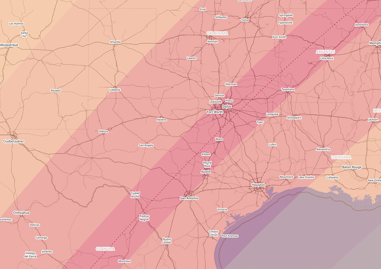
A truly rare event is coming to the DFW Metroplex, a total solar eclipse on April 8, 2024. The map below shows the path of totality of the eclipse in dark pink with the red dashed line representing the center of the total solar eclipse path. The lighter shades represent variations of partial eclipse viewing. As you can see, the DFW Metroplex is in the northwest quadrant of the path of totality. The last time Dallas and Fort Worth experienced a total solar eclipse was on July 29, 1878. We will not experience another one until June 30, 2345. So, it is truly a once in lifetime experience. A total solar eclipse is different than a partial solar eclipse and much rarer. For more information on the upcoming eclipse, please visit: weather.gov/fwd/eclipse2024.
DFW’s mild winter is about to come to an end. A very impressive Arctic airmass will be building and plunged south into the heartland of the CONUS over the weekend, indicative of a ~1045mb high pressure system. This all teleconnected very well with negative EPO, negative WPO, negative AO, and negative NAO. This will produce the coldest weather for this winter by a long shot for DFW. There is an increasing concern that temps could fall below 10°F at the coldest point which is the threshold for severe cold for this region and necessitate Hard Freeze Warnings for the area. This type of cold can damage agriculture and infrastructure this far south as we saw in February 2021. At the very least, we are confident temps will fall to the teens Monday and Tuesday next week for DFW with high temps struggling to get out of the 20s. At this time, it is not anticipated that the cold will be anywhere near the magnitude of February 2021, or last as long. There is a small chance that we may see some impactful wintry precipitation Sunday night into Monday. Not all of the models are on board with this scenario, but enough are that we will be monitoring that closely. Of course, any frozen precipitation will only exacerbate the cold. If you have not winterized your homes, now will be a good time to do so.
Yesterday, the temperature at DFW Airport climbed to a whopping 110°F. The last time this happened was during the hot summer of 2011. Before that, you have to go back to the summer of 2000. This is exceptionally rare, and conditions have to be just right for it to occur. Out of 124 years of weather records, we have only hit the 110°F mark or greater 12 other times. Five of those times occurred during the record breaking summer of 1980. Statistically, this is about a once in a decade occurrence. The hottest DFW has ever been was during June of 1980 when the mercury hit 113°F. Below is table of all the occurrences of temperatures of 110°F or greater in the DFW weather records:
UPDATE: The summer of 2023 now becomes the second year to have more than one day with a temperature at or above 110°F. Yesterday, August 26, 2023 DFW Airport set a record high of 110°F which also broke the daily record. The only other year to have multiple days at or above 110°F was the summer of 1980 (which had 5), as you can see below. This also pushes our tally of a total of 14 – 110°F degree days over our entire weather records history.
During last week’s wintry weather, some locations remained at or below freezing for more than 100 hours. Hearne rose above freezing during each day of the event, but Granbury remained at or below freezing from late Sunday (January 29) until early Friday (February 3), a total of 111 consecutive hours. Officially at DFW Airport, the total number of consecutive hours below freezing was 88 hours. The all time record number of consecutive hours spent below freezing for the DFW Metroplex is 295 hours from 7:00 am December 18, 1983 to 2:00 pm December 30, 1983.